


November 8, 2017 saw the grand opening of the 7th China Surveying, Mapping and Geographic Information Technology Equipment Exhibition (CHINTERGEO Exhibition) & China Surveying, Mapping and Geoinformation Expo in Nanjing. As the largest surveying, mapping and geoinformation expo in Asia, it has been held for 20 consecutively years since it was initiated in 1996. It is a great display platform of the latest products, technologies, equipment, trends and applications in the surveying and mapping industry and a specialized platform that integrates business negotiation, international exchange and brand presentation for enterprises engaged in the surveying and mapping industry. The year of 2017 was a year connecting the preceding years and the following years for China’s Belt & Road Initiative. With the issuance of the new Surveying and Mapping Law, the surveying, mapping and geoinformation industry is faced with a great development opportunity. Themed with innovation-driven and leaping development, this expo attracted more than 200 famous exhibitors, over 500 brands and about 30,000 professional visitors at home and abroad. It presented a magnificent feast of the surveying, mapping and geoinformation industry in Nanjing International Exhibition Center.

Under the guidance of the Ministry of Land and Resources, the China Association for Science and Technology and the National Administration of Surveying, Mapping and Geoinformation, the expo was jointly organized by the China Society for Surveying, Mapping and Geoinformation and China Instrument Manufacturer Association. As Asia’s largest and the world’s second largest leading expo in the surveying, mapping and geoinformation industry, the 7th National Surveying, Mapping and Geoinformation Technology Equipment Exhibition & National Surveying, Mapping and Geoinformation Expo had an exhibition area of more than 20,000m2, and attracted exhibitors from the whole surveying, mapping and geoinformation industry. It sets a new record in Chinese surveying, mapping and geoinformation expos. As a leading enterprise in China’s BDS field, Mengxin Technology was invited to this expo to present high-precision satellite navigation chips/module products, services and system solutions to the industrial experts, upstream and downstream partners and visitors.
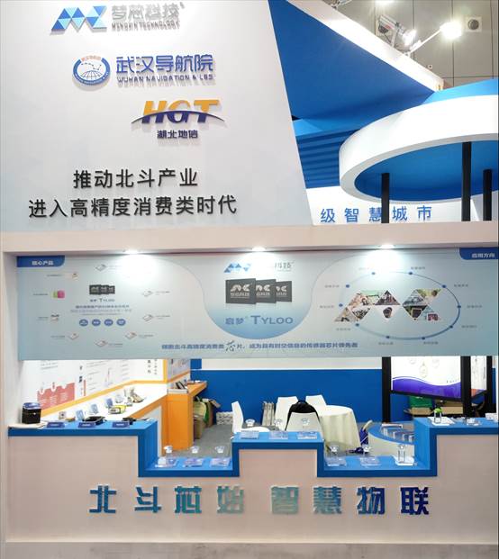
At the expo, Mengxin Technology’s technicians mainly introduced the broadband RF-based system-wide low-power SoC chip—TYLOO MXT2708A, BDS high-precision RTK algorithm-based centimeter-level positioning module and various system terminal products to the guests. These products received high praise from the guests.
Designed and developed based on 40-nm technology, Mengxin Technology’s TYLOO MXT2708A chip is not only compatible with all types of global navigation satellite systems, but also the first to realize that one chip simultaneously receives and processes three kinds of signals—BDS, GPS and GLONASS. Such a chip can be widely applied to automobile, industry, consumer electronics fields. Its high level of integration and multifunction can reduce the size of PCB boards and periphery components to the greatest extent and meet the needs for high-precision consumer navigation and positioning products. Additionally, it is applicable to wearable devices and intelligent IOT terminals.
Mengxin Technology’s BDS high-precision dual-system centimeter-level navigation and positioning module is based on its proprietary TYLOO SoC chip. With built-in RTK algorithm, the module supports BDS B1 and GPS L1, with packages compatible with international mainstream navigation and positioning modules on the market. Featuring high sensitivity, interference resistance and high performance, the module can be applied to high-precision location information services, especially fields with high requirements on precision, such as shared bike parking management, unmanned driving, UAV, robot positioning, surveying, mapping and geoinformation, safety engineering, precision agriculture, and mechanical control.

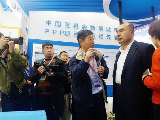
At the expo, Mr. Kurexi, deputy director and member of the Party Group of the Ministry of Land and Resources and director of the National Administration of Surveying, Mapping and Geoinformation, visited the Mengxin Technology’s exhibition stand. Dr. Han Shaowei, chairman of Mengxin Technology, introduced various kinds of high-precision satellite navigation products and technology as well as the development status of Mengxin Technology to him.
Under the guidance of the Ministry of Land and Resources, the China Association for Science and Technology and the National Administration of Surveying, Mapping and Geoinformation, the expo was jointly organized by the China Society for Surveying, Mapping and Geoinformation and China Instrument Manufacturer Association. As Asia’s largest and the world’s second largest leading expo in the surveying, mapping and geoinformation industry, the 7th National Surveying, Mapping and Geoinformation Technology Equipment Exhibition & National Surveying, Mapping and Geoinformation Expo had an exhibition area of more than 20,000m2, and attracted exhibitors from the whole surveying, mapping and geoinformation industry. It set a new record in Chinese surveying, mapping and geoinformation expos. As one of the few BDS chip R&D enterprises in China, Mengxin Technology has been striving to improve product performance in terms of high-precision and high integration level and develop more BDS-based products and solutions for surveying, mapping and geoinformation applications, facilitate industrial development, and allow BDS to better serve the surveying, mapping and geoinformation industry.